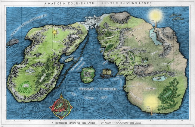
Okay, so maybe you’ve seen a full map of Arda before, but it’s always fun to find a new look at an old favourite. This map really helps to put into perspective the journeys of Frodo and Bilbo, showing that they trek over only a small portion of the entirety of Middle Earth and Arda itself. Like any Fantasy fan, I’m always curious to see what lays beyond the edges of those maps we’re all so familiar with from our countless reads and re-reads of The Lord of the Rings and The Hobbit. From what I understand, this map isn’t entirely accurate, but it’s still fun to peruse.
There’s a lot of evidence that Arda is the same planet we live on, in a different age, and this map showcases some ways in which Middle-Earth and the Undying Lands might eventually become the continents we know today. Or, alternatively, England and Ireland, depending on scale. I also love seeing the ice bridge connecting the northern portions of the two islands/continents.
Hopefully this helps whet your appetite for the upcoming release of The Hobbit, just a few weeks away!

I recognize the map from David Day’s “A Tolkien Bestiary”, but have never seen it coloured in as this one, I like it.
I believe the map is asynchronous, showing aspects of the world together that never co-existed within the works. But it nicely shows the relative positions. Of course other re-constructions show a lot more of Arda to the south. But that might only have come into existence after the fall of Numenor
There’s an error: Lindon isn’t below Beleriand but was directly east of it, leaving Forochel bay open to the north sea since the beginning and not, as the map implies, only after the end of the first age.
I do remember some MERP modules (and a big poster map my friend has) that shows the eastern continent is MUCH bigger, especially to the south.
Yeah, Paul. I think i still have that one in a box somewhere.. Fond memories, looking at that huge map and thinking “why couldn’t we have more stories from that huge world?” when I was a kid. Those last two Istaris are roaming around there somewhere. .
http://www.icewebring.com/ICE_Products/M2/images/2008.jpg
This map is pretty inaccurate, unfortunately – Beleriand lay directly west of Eriador, not north-west as depicted here. The Blue Mountains on the east border of Beleriand were the exact same ones as those on the west border of Eriador, Lindon is the remains of Ossiriand, not a separate area, and Beleriand and Eriador lay at exactly the same latitude. The key clue is the isle of Himling marked on the third age map – this is the same as the Hill of Himring in Beleriand that lay between the Mountains of Terror and the Blue Mountains.
http://images.wikia.com/lotr/de/images/c/ca/Arda3.jpg is a more accurate representation, if less beautifully coloured.
[…] world of Middle-Earth/Arda/Endor, trying to fight off the Amazon Effect for Tolkien. Here’s a pretty good one on Aidan Moher’s blog, which I think comes from one of David Day’s excellent Tolkien […]
Where can one acquire a copy of this map?
Ummmm… this looks almost like Runescape’s Middle earth
it could possibly be new zealand.
it could possibly be new zealand.
I hate to be critical of someone who has done a lot of research and used imagination especially with the hypothetical siting of many areas only described in text, especially in the undying lands. However I agree with some of the other criticisms of the related settings of Beleriand in regards to Eriador. They existed at more or less corresponding levels of latitude separated by the Blue mountains. On this map the Blue mountains have achieved a disproportionate size due to compensating to Eriador being made a much smaller area further to the south of Beleriand. This would also cause conflict for any climatologists as Beleriand in Tolkien’s creation is regarded as a very hospitable climate as compared to Eriador which is regarded as temperate at best. As Tolkien appeared (at least in regard to Middle Earth) to recognise a world where there was temperature increase as one journeyed south, this would put these parts of the map distinctly out of sync. Further more this has created a map depicting the Blue mountains to be disproportionately huge compared to the Misty mountains. If you read the early parts of the Silmarilion there is a passage that refers to Morgoth rearing the “Towers of Mist”(Misty Mountains) to obstruct the passage of Orome. These mountains are referred to as the greatest in the world and I believe the map should reflect this.
I don’t like being such a hard-nosed critic regarding these details but I have enjoyed all of this for many years. I was sixteen when I read the Lord of the Rings and it remains my all time favourite book. I have enjoyed your artwork and the whimsical situations of locations. I hope you can make a more accurate representation of the map. I am not the artist you are but I might be able to provide some insight.
[…] A map of Middle Earth as you’ve never seen it before; and […]